 Source: NC Encyclopedia at ncpedia.org
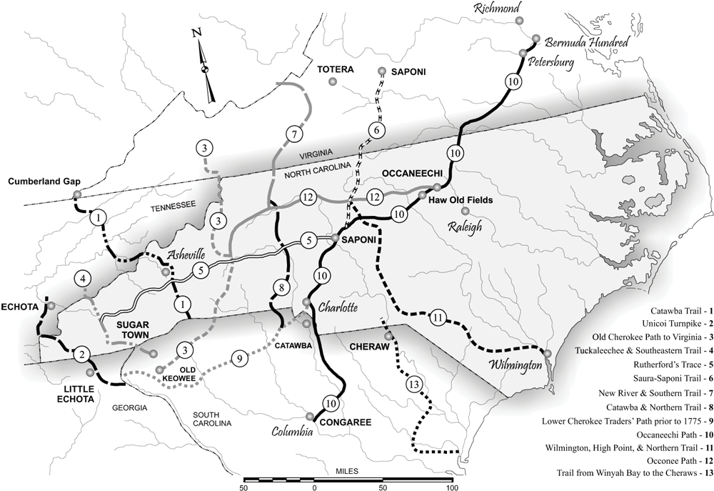
What happened to the English colonists of the ill-fated Lost Colony on Roanoke Island? Theories spring up like crocus in a lawn, only to vanish in the heat of closer examination. The Dare Stones, once considered to be entirely faked, have recently been brought to light again through the controversial TV series America Unearthed episode "Mystery of Roanoke." What is interesting to me about the Dare Stones is the lengths to which people will go to defend their pet theory, rather than investigate to uncover the truth. Just to go on record from the beginning, I'm not at all persuaded that most of the Dare Stones are real. In fact, I think most of them are fakes. But I find the original and a few of the later Dare Stones to be compelling and worthy of further examination. My reason for this rests partly on the trajectory of the Occaneechi Path. The Dare Stones imply that Eleanor Dare (daughter of Governor John White) and a few surviving colonists went southwest, away from the coast of North Carolina and deep into South Carolina and even western Georgia. On the surface of it, this theory sounds preposterous. Why would the remnants of the colony and possibly also a few surviving Croatoan Indians go in that direction? How would they even get to Georgia through hundreds of miles of dense forest and numerous river crossings? The Occaneechi, or Great Trading, Path provides an answer. It began on the James River in Virginia and headed southwest to the Roanoke River near the Virginia - North Carolina border. There, on an island in the river, the Occaneechee Indians held their place as great traders along the upper portion of the Path. (The Roanoke River empties into Albemarle Sound farther east, in coastal NC, not far from where Roanoke Island and Croatoan Island lie at the mouth of the sound.) After leaving the coastal plain, the Path pushed westerly through forests and across more rivers to what is now Asheboro, NC, then headed more southerly toward Charlotte, NC. From there, it split into an eastern branch that led to Columbia, South Carolina, and a western branch called the Lower Cherokee Trading Path, which ended near Little Echota, in Georgia. John Lederer, one of the first explorers of the Carolina backcountry, clearly notes the Path on his map from the 1670s, so we know it was in use before his time, and probably for centuries prior. The Native peoples were sophisticated traders and travelers, as their own stories and beliefs attest, and numerous archaeological finds have demonstrated. Thus, there is some logic in the theory that Algonquin Indians from Croatoan, having befriended the English camped on Roanoke, might have led them to safety among their trading contacts in the west, the powerful Itsate Creek people living in northeastern Georgia [not Cherokee before 1700s]. This is precisely where some of the Dare Stones say Eleanor Dare went. Coincidence? Or a clever hoax? Let me know what you think. In my next post for "Dare to Follow," I'll explore some theories on what caused the English to vanish from Roanoke Island.
Carol Hardy Bryan
4/4/2020 10:05:38 am
I am almost certain of another fork in the Occanochee Trail that led from the Catawbas to Saluda Old Town and on to Augusta. Portions of the old trail are still visible locally in Saluda and Edgefield Counties. To go down to the Congarees before going to Augusta would be much out of the way. 4/6/2020 03:29:28 pm
Thanks, Carol. Since 2014, I've become convinced that the later Dare Stones are fakes and that Eleanor and the survivors of the Roanoke - Chowan colony did not go south along the Trail. But the true extent of the Trail is a fascinating piece of Carolina history in itself, worthy of its own exploration, and with modern GPS tagging, marking for future preservation. 4/7/2022 09:34:29 pm
What an exquisite article! Your post is very helpful right now. Thank you for sharing this informative one.
Carol H Bryan
4/8/2022 09:35:42 am
Who would be the proper authorities to research the path from Saluda Old Town. For history's sake it should be followed and marked. I live in Edgefield County and am convinced that what I propose is true, but in no way know how to proceed to prove it. That would be the trail that most migrants followed in the early settlement of this portion of the Back Country. As an aside another path crossed it not far from my home and it was the Keowee Trail that led to the coast near what is now Charleston well before Ninety Six was settled. The path is still visible in front of Little Stevens Creek Baptist Church and crosses Little Stevens Creek and joins up with what is now the Long Cane Road later layed out by Patrick Calhoun for the Palatine settlement.
Hi, Carol. The Trading Path Association can be found at: http://tradingpath.org/
Carol H Bryan
4/9/2022 06:05:41 am
Thanks for the heads up on the trading path organization. Comments are closed.
|
