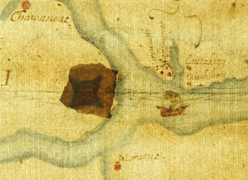
Detail from the Virginia Pars Map, drawn by John White c. 1587, showing fort-like structure under a patch contemporary with the map, at the head of Albemarle Sound, NC. Source: British Museum collection.
Last time, I suggested that the Lost Colony of Roanoke may have left the island for a location indicated by the Dare Stones. After additional research -- including examining the text of each known Dare Stone, where first discovered if known, and comparing that information with historical and geographical sources -- I have concluded that most of the Dare Stones, including the first one, are genuine and not fakes. [But see my July 29, 2015 entry.] Some, however, are clearly faked and the information and wording is either completely wrong or simply copied from previously discovered stones. These have served for almost 75 years to discredit the remaining stones, which are very convincing. If the believable Dare Stones are fakes also, they were created by experts in the field of 16th century English speech, Native American history, and the geography of North and South Carolina and northeastern Georgia, not to mention possessed of the complete list of names of the lost colonists.
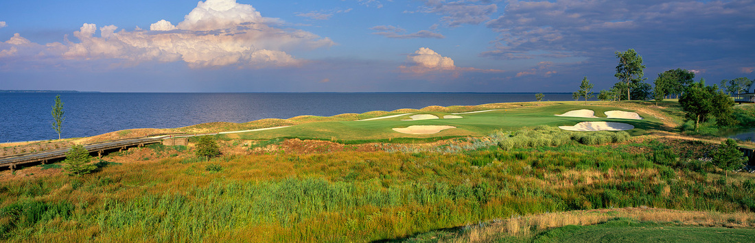
That said, I believe the colonists divided into at least two groups shortly after John White, the governor and Eleanor Dare's father, returned to England in August, 1587, to obtain much needed supplies. The colony could not have arrived in the New World at a worse time and place. Although their official destination was the Chesapeake area in southeastern Virginia, their ships' captain put everyone ashore on Roanoke Island in eastern North Carolina. Claiming the weather was about to turn, but in reality wanting to prey on Spanish treasure vessels, he waited only long enough to unload the ships and take on fresh water before leaving with Governor White. The coast of North Carolina was experiencing the worst drought in 800 years, according to recent data from tree rings. So all the Native peoples were in turmoil, trying to guard their corn fields from raids by neighboring tribes. To the north, along the present-day Virginia - North Carolina border, the Powhatan Confederacy was forming under their chief of chiefs, Wahunsunacoc, known better to us as Powhatan, the father of Pocahontas. He imagined a great unified empire of Algonkian-speaking peoples, and the peoples of coastal NC were primarily Algonkian speakers, like the Croatoans. Manteo, a Croatoan who had traveled to England in 1584 and returned to his homeland, served as the colony's translator. He also tried to obtain adequate food for the colonists, but his people were a small tribe, and would not have had sufficient resources to feed 115 additional people during a severe drought. Worst of all, England was gearing up for a prolonged war with Spain, which would end only in late 1588 with the destruction of the Spanish Armada. No seaworthy ships could (or would) be spared by Queen Elizabeth to resupply the colony. They were stranded, in every sense. Documents and maps from the period, however, offer clues to the colonists' fate that have not been taken seriously up to now. The Virginia Pars Map, shown above, was re-examined in 2011 and found to have a fort-like structure covered under a mysterious "patch." The map was created by Eleanor Dare's father, John White, from observations he made while serving as naturalist and cartographer for the 1585-6 voyage to Roanoke, under Ralph Lane. As Lane's Narrative of the Settlement of Roanoke Island, 1585-1586 explains, the mainland at the head of Albemarle Sound was explored, as well as the lower reaches of the Chowan and Roanoke rivers. Located between the two rivers, the land rose into a hill now known as Merry Hill, NC, with excellent views of any ships approaching up Albemarle Sound. This is the exact spot marked with the "fort" on the Virginia Pars map. The extreme point of the hill is now a golf course, but the "fort" is located slightly to the southwest on the map. Lane describes the area thus, "Between Muscamunge and Choanoke upon the left hand as we passe thither, is a goodly high land, and there is a Towne . . . and hath a very goodly corne field belonging unto it: it is subject to Choanoke." Here, "at the head of the [Chowan] River in the place of my descent" Lane desired "to have raysed a sconse [small fort] with a small trench, and a pallisado upon the top of it." This would be only the first in a series of forts he recommended up both the Chowan and Roanoke rivers, and overland through central Virginia to avoid the Powhatan Confederacy, to reach both copper mines in the Appalachians and oyster beds in north Chesapeake Bay, where pearls were found in abundance. Like most English colonists, Lane saw North America as a land for the taking, rich with natural resources to be exploited for profit. The "savages," as Native Americans were called then, were just minor obstacles to be pushed aside if they showed any resistance. The Native peoples, however, were far more complex and sophisticated than Lane or any of the English could have imagined. Despite the drought, both the Croatoans on the coast and the Choanokes on the mainland showed generous hospitality and patience to the English. The Choanokes, particularly, were a numerous people and had prosperous villages all along the Chowan River basin. Their chief, Menatonon, remained friendly to the English even after Lane had taken him prisoner for two days, forced his people to pay a ransom, and then took his son hostage instead. Menatonon could reportedly put 700 warriors into the field from his main town alone, yet he refrained from showing hostility toward the greatly outnumbered English. So the point at Merry Hill was a likely spot for a future settlement -- it was defensible from the Spanish, it had good fields for growing food, it offered quick access to the supposed riches of the mainland, and it was protected (and initially supplied) by a powerful and friendly Native tribe. No wonder John White marked it on his map. Furthermore, it was about 60 miles "further up into the maine" from Roanoke Island. John White's Narrative of the 1587 Virginia Voyage puts the mileage at 50 instead of 60, but clearly he is not referring to the Chesapeake area, some 130 miles to the north. Why, for almost 100 years, has no one searched at Merry Hill for evidence of the Lost Colony? The first, and most credible, Dare Stone, dated 1591 and signed by Eleanor Dare, was found just 4 miles from Merry Hill, near Hwy. 17, not far from the site of the Choanoke town. The Roanoke River, on the west side of Merry Hill, leads directly upriver to the Occaneechi Path. Satellite images of Merry Hill, just southwest of the modern golf course, show what appears to be the outlines of a small fort, including a moat and extended gate wall, in the leveled soil of a plowed field.
We still have much to learn about the Lost Colony! While I agree that the main body of the colonists were intended for the Chesapeake, and probably all moved to Croatoan for the winter of 1587, as the "CROATOAN" sign famously suggests, I believe a number of colonists also went to Merry Hill in 1588, as the first Dare Stone claims. If so, it would prove to be only a stopping point on Eleanor Dare's amazing journey into America. Next time, I'll take a closer look at the Occaneechi people for whom the trading path is named.
|
